top of page
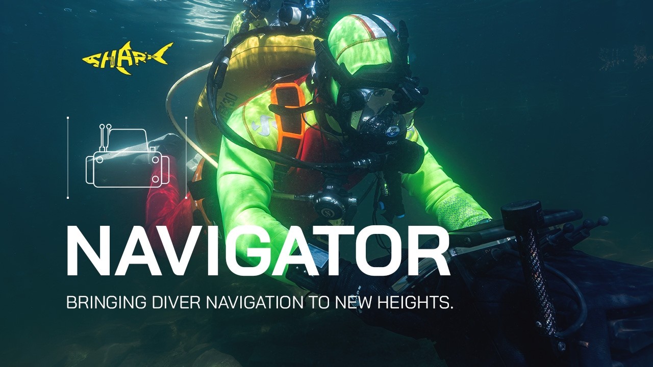
Public Service Diver prepping with the Navigator Sonar Unit
Gradient
Gradient
Bringing diver navigation to new heights.

Navigator

The Navigator is a second generation Sonar Imaging and Navigation System, designed by Shark Marine primarily for MCM and SAR use.

Public Service Diver planning a dive.

A one man Navigation and Sonar Reconnaissance unit.

The Navigator is in use by many of the world's Navies, and has become a trusted piece of their standard kit and reshaped many of their SOPs.  The modularity of the system and numerous advanced sensors available allow the Navigator to become a force multiplier, enabling smaller groups to cover more ground in less time.

Many Police forces and Fire Departments are also using the Navigator in homeland security / search and recovery roles as well as scientific organizations, and commercial dive companies.

Public Service Diver gear check.
Public Close up of the Navigator being operated by a Public Service Diver on mission.

The Navigator is the most modular system of its kind, enabling it to be quickly configured for any application.  The modularity of the system also means that it will never become obsolete, as technology advances in certain areas these components can be replaced, rather then needing to replace the entire system.  Shark Marine’s DiveLog software controls all operations of the navigator and its accessories, operators need only learn one software to master all their equipment.

Public Service Diver on mission in zero visibility conditions.
Public Service Diver gear check.
Close up of the Shark Marine Navigator unit
Gradient
Gradient
Innovations for Maritime Security
07:05

Innovations for Maritime Security

A brief overview of Shark Marine Technologies Inc's SeaSar search and recovery system, along with the Navigator diver operated sonar imaging and navigation system, and STEALTH 2 Remotely Operated Vehicle
Navigator
02:58

Navigator

Shark Marine Technologies Inc's NAVIGATOR diver held sonar imaging and navigation system.
Shark Marine Technologies Inc - Navigator for Mine Countermeasures (MCM)
04:36

Shark Marine Technologies Inc - Navigator for Mine Countermeasures (MCM)

Shark Marine's Diver Held Navigation and Sonar Imaging Systems have been tried, proven and are in use by Navies, Police Forces, and Scientific Groups across the globe.
Navigator right side view
Navigator front view
Navigator left side view with Navcam and Doppler navigation system.
Navigator

Military / Law Enforcement Applications:

Mine Counter Measures

Rapid Beach Profiling / REA

Explosive Ordnance Disposal

Sub Sea Communications

Search and Recovery

Homeland Security

Covert Navigation

Evidence Recovery / Documentation.

Commercial Applications:

Infrastructure Inspection

Pipe and Cable Tracking

Scientific Applications:

Underwater Archaeology

Habitat Mapping

Coral Research

Accessories:

Surface GPS

Surface GPS:

The Surface GPS can be used when the Navigator is functioning on the surface. It also works well as a rapidly deployed system where it would provide the initial position fix for the DNS.

Navigator F GPS Side Profile

Floating GPS:

The Floating GPS provides positioning in shallow waters. This system can also be periodically deployed to the surface to remove any time accumulated error when using the DNS for long range covert operations.

Navigator Pole GPS

Pole GPS:

The Navigator Pole GPS was designed for use with the Rapid Beach Profiling system, or other applications where the operator will be swimming on the surface.

Doppler Navigation System (DNS)

Doppler Navigation System (DNS):

The Doppler Navigation System tracks the divers movement over the sea floor. As a result it does not require a satellite fix or base stations once its initial position has been set. The DNS is an ideal set up for covert rapid deployments (when paired with the surface GPS) or to fill in any gaps caused by acoustic shadows when using the LBL system.

Shark Marine Logo Place Holder

Long Base Line (LBL) Positioning System:

Shark Marines LBL system provides high precision underwater navigation without the need for a floating GPS or tethers to the surface. This system can use 2 or 3 base stations which can be rapidly deployed from any small craft or by a diver. The LBL is the system of choice for any long duration underwater searches.

Shark Marine Logo Place Holder

Motion Reference Unit:

The Extended MRU option provides the Navigator or Dive Tablet with a more accurate compass and full 360 degree pitch and roll orientation data. Highly recommended for use on the Navigator with forward-looking sonars and the Doppler Navigation System for more accurate positioning.

Shark Marine Logo Place Holder

Forward Looking Sonars:
P-450 Series – Long Range:

The P-450 series forward-looking sonar is the best solution to detect, monitor, and track objects and/or targets at distances up to 300 meters (984′). The P450 is available with a 45°, 90°, or 130° field of view. Frequency: 450 kHz Range Max: 300 m (904′)

Shark Marine Logo Place Holder

Forward Looking Sonars:
P-900 Series – Mid Range:

The P900 series forward-looking sonar is the ideal sonar for underwater detection and identification operations up to 100 meters (328′). The P900 series is also available with a 45°, 90°, or 130° field of view. Frequency: 900 kHz Range Max: 100 m (328′)

Shark Marine Logo Place Holder

Forward Looking Sonars:
P-900-2250 Mid – Short Range:

The P900-2250 forward-looking sonar combines a medium range 900-45 navigation and inspection sonar with the identification capabilities of a higher frequency 2.25 MHz sonar head. Frequency: Selectable 900 kHz 2.2MHz Range Max: 100 m(328′) 900kHz 12 m (39′) 2.25MHz

Shark Marine Logo Place Holder

Forward Looking Sonars:
Sound Metrics Aris:

The Sound Metrics Aris sonar is a dual frequency unit that provides extremely high resolution imagery at short range, well suited for detailed inspections and target identification. Frequency: Selectable 1800kHz, 3000kHz Range Max: 15 m (50′) 1800kHz and 5 m (16′) 3000kHz

Forward Looking Sonar

Forward Looking Sonars:
Tritech Gemini:

At 720kHz the tritech Gemini is well suited for medium to long range searches (120 m (394′)). The wide even image of the Gemini allows this sonar to make very clean mosaicks. Its small size also make it a perfect fit for Shark Marine’s Navigator DT2 system. Frequency: 720 kHz Range Max: 120 m (394′)

Pro-Mag 2 with Navigator

PRO-MAG - Magnetometer:

The PRO-MAG is a high sensitivity Overhauser Magnetometer that can be equipped on the Navigator to locate objects with ferrous content.

Nav Metal Detector front view

725K Metal Detector:

The Ebinger 725K is a field proven, valuable tool for underwater ordnance detection. When integrated with the NAVIGATOR its abilities are further enhanced with the addition of a visual data display and the navigational features of the system.

Navigator Radiation Detector

Radiation Detector:

The Shark Marine radiation detector is a plug and play unit designed to detect gamma radiation underwater.

Navigator Altimeter-Sonar

Bathymetric Sonars:
Sonar Altimeter:

The Sonar Altimeter measures the distance to the seafloor. The Sonar Altimeter can also be used to gather bathymetric / beach profile data.

Shark Marine Logo Place Holder

Bathymetric Sonars:
Multi-Beam Profiler:

The Multi-Beam Profiler can be used to gather bathymetric data. The Multi-Beam covers a much larger swath then the Sonar Altimeter.

Shark Marine Logo Place Holder

Bathymetric Sonars:
Transom Mounted Altimeter Sonar:

The Transom Mounted Altimeter Sonar is used for the Rapid Beach Profiling System (RBPS). It was designed to quickly mount to vessels of opportunity for collecting bathymetric and beach profile data.

UHMD-1 Underwater Head Mounted Display

Underwater Head-Mounted Display (UHMD):

Designed for use in zero visibility situations, or for operations where a low light signature is required, the Underwater Head Mounted Display (UHMD) brings the NAVIGATORS display right to the divers mask. The UHMD is available as a monocular or binocular version. Mounts are also available for different masks or helmets.

Navigator AMU Side Profile

NavCam:

The NavNam is a plug-and-play digital camera that mounts onto the Navigator. It can capture still images up to 1920 x 1080 and video up to 1280 x 720, which are geo-referenced (if a position is available), and digitally stored in the DiveLog project.

SubNet Communications Systems Diagram

Sub-NET Communications System:

Sub-NET is an underwater communication system that allows multiple Navigators to communicate with one another or to surface vessels or other assets. Sub-NET also allows connected Navigators / other assets, to share their locations with one another, as well as send target information and waypoints.

Mako Diver Delivery System

MAKO Diver Delivery System:

The MAKO DDS marks a new evolution in diver transportation by combining a propulsion device with the Shark Marine Navigator. The combination provides a system that is capable of automated flight paths, from a simple “Goto Target” to complex survey routes, while providing the diver with full navigation and forward looking sonar imagery to locate and view targets up to 300 meters (904′) away.

Shark Marine Logo Place Holder

DPV Mounts:

The Navigator system can be mounted to many different Diver Propulsion Vehicles. Contact us with your specific needs in this area.

Nav Light

NAV Light:

The Nav Light provides even lighting to aid in capturing video or still images of targets using the NavCam. Can also be used simply for the diver’s vision. Brightness: 1300 Lumens.

Pole Mounted Sonar System

Pole Mounted Sonar System:

Designed for boat operations the Pole Mounted Sonar System allows the operator to search large areas with geo-referenced forward looking sonar, and collect bathymetric / beach profile information.

Let's Work
Together

Phone: 1 (905) 687-6672

sales@sharkmarine.com

23 Nihan Drive

St. Catharines, L2N 1L2, Ontario, Canada

  • Instagram
  • Facebook
  • Youtube
  • LinkedIn
bottom of page